A Self Guided Driving Tour Of Perry County Pennsylvania
Created 2010 by David Taylor
Revised 2022
This self guided driving tour of Perry County takes you through some of the most beautiful scenery in Pennsylvania. The entire tour covers approximately 200 miles. It starts and ends at Amity Hall at the Dauphin and Perry County line. Along the way I will point out many historical sites and buildings. You will pass many businesses, shops and restaurants. As you travel the roadways of Perry County several large blue state historical markers will be pointed out to you. You will also learn about some of the history and folklore of the area. You will see all 14 covered bridges and several old grist mills. Take your camera along with you for that very special “Kodak moment.”
Plan on taking several days to complete the entire tour because there are many things to see and do along the way. You may want to travel some of the same roads in more than one season to see how diverse they appear during various times of the year. Many areas will look quite different when there are no leaves on the trees and snow covers the ground.
Have a pleasant and safe journey and enjoy beautiful Perry County.
The tour starts at the Dauphin / Perry County line north bound on routes US 11/15 just north of Amity Hall, or the north bound ramp from US 22/322.
Just a few hundred yards north of here you will find the first of 12 large blue state historical markers located at the entrance to Haldeman Island Wildlife Preserve. This marker is for the Pennsylvania Canal (Susquehanna Division) built 1828-31 and operated until 1901. The canal extended from here at Duncan’s Island north to Northumberland, PA a distance of 41 miles and embraced 13 locks and 7 aqueducts.
Continuing north 0.9 miles and turning left on Old Trail Road, just past New Buffalo Alliance Church will lead you to the Borough of New Buffalo, the smallest borough in the state of Pennsylvania.
New Buffalo was named for the bison that crossed the river near here many years ago. Take a slow drive through town and return to US 11/15 at the north end of town. As you continue north from New Buffalo you will pass Clemson Island River Access Area and see breathtaking views of the beautiful Susquehanna River on your way to Girty’s Notch 3.1 miles up the road. Legend tells us that near this location a renegade known as Simon Girty lived in a cave high on the mountain to keep an eye on the river traffic and escape the long arm of the law. However, some say Simon Girty was never in this area. You decide which story you want to believe.
A little farther up the road you will pass a few houses on the left known as the village of Montgomery’s Ferry, where a river crossing ferry was established around 1828 by William Montgomery. A little farther north you will find the Montgomery Ferry River Access Area.
Near the intersection of SR 34 and US 11/15, 4.6 miles north of Girty’s Notch, you will find the second state historical marker for the Millersburg Ferry. Turn right to enter Ferry Boat Campsites, the western landing for the Millersburg Ferry, formerly Crows Ferry. Ferry service was started here in 1817. This is the last vehicle carrying, stern wheel ferry still in operation anywhere in the United States. You can take a ride across the river and back as a walk-on passenger during the summer months to experience travel as it was done over 100 years ago.
As you return to US 11/15 you can see remains of the old Pennsylvania Canal on both sides of the road.
Still traveling north on US 11/15 go 4.6 miles to the town of Liverpool. Turn left at the north end of town onto Front Street at the Lutheran church. Continuing south on Front Street you will find the former E. K. Freed’s & Son Feed Mill. The original mill built by Edward and Daniel Freed in 1940 was two blocks from this location. It was destroyed by fire in 1960. This mill was originally the H. A. Long Warehouse that Freed purchased, along with all of the milling equipment, after the fire destroyed his other mill. This mill remained in operation grinding feed until the last day of 1977.
Continue on to the stop sign. Just ahead on the left are the historical marker and the home of Dr. Elizabeth Reifsnyder M.D., a pioneer medical missionary to China. Drive south on Front Street and turn right on Walnut Street (next street to right) go 1 block and turn right on Market Street to the town square. Its lovely band shell sits on the grassy common. Many of Liverpool’s residents live on the hill behind town and have a very picturesque view of the Susquehanna River from their front door or back yard. Turn right at the stop sign and go 1 block passing the Post Office to Front Street where you will turn right again. From here go south on Front Street, crossing SR 17 and turn right just past the town park on to Perry Valley Road (SR 50001). Travel 1.0 mile and turn right on Red Bridge Road (SR 50023) where you find Red Bridge, the first of Perry County’s 14 covered bridges. This bridge is owned and maintained by the Historical Society of Perry County.
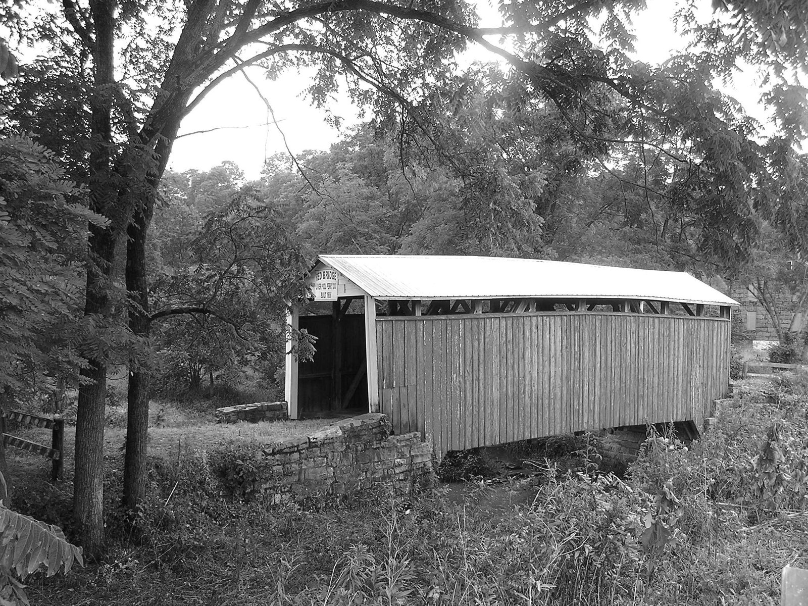
Red Bridge
Continuing past the bridge 1.3 miles you will come to SR 17 again. Straight through at the intersection will put you on SR 17 south. As you pass through this valley you see many eye-pleasing views of Perry County farms and homes.
Your next stop is Millerstown, 8.2 miles, the oldest town in Perry County. In the square you will find a state historical marker for James A. Beaver (Governor of Pennsylvania 1887 to 1891 and Superior Court Judge 1895 to 1914). Just west (right) of the square you will find the Cochran-Anspach house, one of the 14 stone structures in town. Most of these structures were built in the late 1700’s and early 1800’s. Ten of these structures are visible if you are standing in the center of the square. Millerstown has more stone structures than any other town in Perry County. If you travel up and down Main Street you will see all of these beautiful buildings except the two you passed as you entered the center of town on Sunbury Street (SR 17).
The Cochran-Anspach house, just west of the square, (to your right) is owned and operated by the Historical Society of Perry County. It is open to visitors by appointment or on special occasions. It can also be rented to hold small dinner parties and meetings.

Cochran-Anspach house
Return to the center of town, turn west to cross the Juniata River and continue south on SR 17. Just 0.5 miles from town on your right you will see a one room brick school house, known as River School or Number 7 School, furnished as it was when it was last used in the 1950’s. Less than a mile on up the road, on your left, you will see one of Perry County’s icons, Hall’s Dairy. The dairy has been making ice cream in the county since 1947. William J. Hall delivered milk to homes in the Millerstown area beginning in 1905. About 1.5 miles up the road, on the left, is a bison farm. If you are lucky the bison may be grazing next to the highway for you to get a close-up look at these magnificent animals that once roamed free in this area. The next farm on the right is one of Perry County’s picturesque dairy farms. It has been in the Bratton family for many years.
Now it’s on to the village of Donnally’s Mills where you will see one of Perry County’s old grist mills on the left beside the old stone house. The first mill was built in 1763 and replaced in 1836. The mill was once operated by the Donnally family thus giving this community its name.
To your right on the other side of this community you will see one of many large bank barns in the county. This one is on what is currently the Lewis and Connie Byers farm. As you travel the next few miles you will see several more typical Perry County farms including the Barnes Homestead on the right, about a mile from the village of Ickesburg where the high power voltage lines cross the highway.
Ickesburg was once a very prosperous community for commerce because of its location at the intersection of SR 17 and SR 74 which was the main route over the mountains between Port Royal in Juniata County to the north and Carlisle in Cumberland County to the south. Today it is just a sleepy little community where residents enjoy peace and quiet.
At the west end of town turn right on Liberty Valley Road (SR 50012) and go 2.5 miles to the village of Saville. Here you will find the second covered bridge of the tour. Turn left at the stop sign and drive through the covered bridge. This bridge is owned by the state of PA and was completely reconstructed in 2007. Continue on to SR 17, about 1 mile. Turn right, then a quick left on Fritz Road and you will come to the Kochenderfer Covered Bridge. The Kochenderfer bridge is owned by the county. Turn around and return to SR 17, (Tuscarora Path), turn left, travel 3.7 miles to the village of Kistler. Here, from the stop sign, look closely at this bridge at the intersection of SR 17 and SR 850. This may be the only place you will ever see two roads intersecting in the middle of a bridge. From here drive west on SR 17 5 miles, past many beautiful farms and rolling hills, to the borough of Blain. Along the way you will pass an Amish school house on the right at Red Bird Road 2.5 miles from Kistler. Many of the farms in this area are owned by Amish families.
At the stop sign in Blain turn right onto SR 274 and go about 4 miles to New Germantown. On your way there are two more covered bridges over Shermans Creek to your left. They are Book’s Covered Bridge (rebuilt in 2004) on Three Springs Road one mile from Blain, and Mount Pleasant Bridge on Mount Pleasant Road 1.2 miles on up the road.
Both bridges are just a short drive off SR 274. Return to SR 274, turn left and you will come to New Germantown, the western most municipality in Perry County.
In New Germantown turn left on Lower Buck Ridge Road where you will find the New Germantown rail road station on the left. It was once part of the Shermans Valley Rail Road. Just past the rail road station you will find the New Germantown Covered Bridge. After your visit here turn around and return to the main street, SR274, and turn left.
Continue through town to the Tuscarora State Forest Regional Headquarters. Stop in and pick up a map of the area showing roads and trails. Other information on the area is available as well.
Going 1.6 miles farther west on SR 274, will bring you to Fairview Church on the right, a one room brick church owned by the Historical Society of Perry County. Services are held here several times a year on special occasions. The church is available to be rented for weddings or other occasions.
Most of the private properties along this road are used as seasonal retreats and hunting camps.

Fairview Church
From the church, continue 3.4 miles farther west to Hemlock Road in the Big Spring Picnic Area, formerly Big Spring State Park. Hemlock Road leads to the Hemlock Natural Area and many hiking trails. One of the trails leads to the entrance of an old railroad tunnel that was started around 1894. The project was discontinued about a year later due to the lack of solid rock on the west end of the tunnel, (other side of the mountain) and the fact that the project was more difficult than expected.
On some of the park maps several hiking trails are marked as well as the location of the Big Spring. A parking area for these trails is on the left side of Hemlock Road, just off SR 274. If you drove west on SR 274 from here just a few miles to the top the mountain you would be in Franklin County.
Continue on Hemlock Road 2.3 miles (see note below) to the Hemlock Natural Area and view some of the only virgin hemlocks remaining in Pennsylvania. Continue 5.2 miles to Upper Buck Ridge Road and turn left to return to SR 274 near the Tuscarora State Forest Regional Headquarters. Turn right to return to Blain.
NOTE: If you do not wish to drive the 7.5 miles of dirt road through the Hemlock Natural Area, turn around and return to Blain via SR 274.
If you are hungry and would like to step back in time for lunch you can stop at the Blain Hotel near the intersection of SR17 and SR 274. They have good home cooked meals.
Once in Blain continue east on SR 274. Where SR 274 turns left, go straight ahead on the dead end street (Church Street) to the Blain railroad station. This station was part of the historic Shermans Valley Railroad. Today it is used as local museum for the community.
Read the next paragraph carefully before proceeding because you will be making a lot of turns in a short distance.
Return to SR 274. Turn right, then another right, on Manassa Road, then left on Elsie Circle, after crossing two concrete bridges. Turn left on Adams Grove Road and travel 0.2 miles to Enslow’s Covered Bridge. Pass through the bridge and turn left. Go 0.5 miles, turn right on Red Rock Road and travel 1.6 miles to Bistline Covered Bridge. The bridge is on the right behind the trees at the stop sign. Turn left at the stop sign, onto Bistline Bridge Road. Go 0.8 miles and take Madison Road to SR 274 (Shermans Valley Road). Turn right at SR 274 and go east 0.8 miles to Couchtown Road (SR 3008) to Adair’s Covered Bridge at Cisna Run. This bridge is owned by the state of PA and was completely reconstructed in 2007-2008.
Return to SR 274, turn right and continue east 2.5 miles to SR 850, turn left, travel about 0.8 miles to a stone marker along the road near the site where Fort Robinson is believed to have once stood. This fort was built in 1755 to protect the settlers from Indian attacks. Over the past few years the archaeological division of the historical society has tried to determine the exact location of the fort but have not yet found it at this time.
Just past the fort site you will find Centre Presbyterian Church. This church was started in 1766 with the first log church being erected in 1767. The church was incorporated on March 24, 1819. In the early days two men would stand guard with guns to protect the worshippers from Indian attacks.
Turn around in the church parking lot and return to SR 274. As you approach the stop sign look straight ahead at the house across the road. You will find a green gate giving the house its name “Green Gate,” a local land mark. Just to the left of the house is a state historical marker for Fort Robinson. Turn left onto SR 274.
Just around the corner on your left on SR 274/850 is Waggoner’s covered bridge on the left. This is the second covered bridge owned by the historical society.
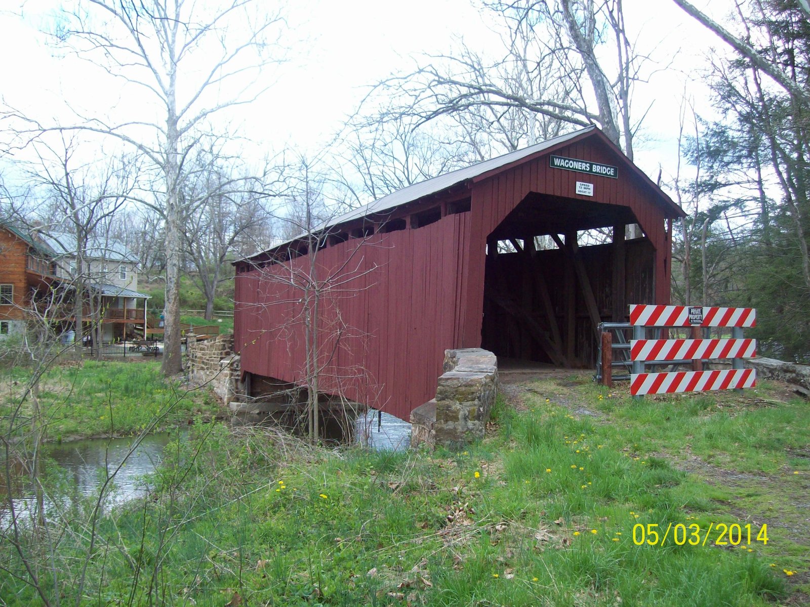
Waggoner’s Bridge
Unfortunately, in 2021 arsonists burned this 19th century covered bridge, probably the most photographed of all the county’s attractions. The preservation and protection of these priceless heritage pieces requires the vigilance and care of all citizens.

Bernheisel or Green Park School
Continue past the school to the stop sign, turn right on SR 74 and proceed to the stop sign at SR 274. Turn right on SR 274, return to the intersection of SR 274/233, turn left on SR 233 and travel 2.7 miles to the borough of Landisburg.
The Fetter House is the second house on the right past the SR 233/850 intersection ahead of you.

Fetter House
The Fetter house is used as the headquarters for the historical society and is open to the public for tours on special occasions.
One block past the Fetter House, turn right on Kennedy Valley Road. Just outside of town you will find Rice’s covered bridge.
After your visit here turn around and return to Landisburg. Turn right at the stop sign onto SR 3017 to Bridgeport. At the stop sign in Bridgeport turn right onto SR 74 and cross Shermans Creek where you will find one of two old mills in the county that is operated by H.R. Wentzel & Sons. Stop in and ask to have a look around if the mill is open. This mill was built in 1805 and is known by several names: Waggoner’s Mill, Snyder’s Mill or Hooke’s Mill because men by these names once owned and operated this mill.
Turn around at the mill, go back across the creek and turn right on Pine Hill Road. Turn left on Warm Springs Road (2nd road on left) go 1.2 miles, and travel along Shermans Creek 1.6 miles until you come to Warm Springs Lodge. The original lodge was built in 1832. In the late 1800’s and early 1900s Warm Springs Lodge was “The Place to Be” for high society from New York, Philadelphia and Baltimore, to bathe in the warm mineral springs for medicinal purposes. In the meadow between the lodge and the creek is the location where the only recorded dual was fought in Perry County. It was between two men from the Baltimore, MD area over the favors of a woman from the same area. Swords were the selected weapons. The dual was of short duration with only one man walking away, but the survivor ended up being killed himself three weeks later by a falling brick in Baltimore.
Continuing past the lodge 1.9 miles to the second stop sign you will find SR 850. Turn right and go 0.6 miles to Gibson’s or Westover’s Mill, built 1778 by Ann West Gibson. She was the mother of John Bannister Gibson who became Chief Justice of the Pennsylvania Superior Court serving from 1827 to 1851. The Westover name came from the West family coming from Westover England. Before you reach the mill, on the same side of the road, you will find a state historical marker for John Bannister Gibson.
Continuing past the mill 0.3 miles you will come to Gibson’s Rock, an important landmark in Perry County history. Over the years many accidents happened at this rock and a number of people have lost their lives at this location. In the very early days of settling this valley, wagons were lost when they tried to go around the rocks before there were any roads in the area. Today’s drivers lose control on the curve for various reasons, especially when they had a little too much to drink.
Turn around now and follow SR 850 back to SR 74 (4.4 miles) to Alinda where you will turn right and go one mile to SR 50006, (SR 74 goes left, you keep straight) on Little Germany Road 2.2 miles to find Ludolph Church on the right. The church was built in 1842 and was used by both the Lutherans and Reformed faiths to worship until 1869 when the Lutherans built a new church in Elliottsburg. In 1872 the Reformed congregation also built a new church in Elliottsburg, abandoning the stone church. It has not been used since except for special occasions. The Historical Society of Perry County purchased the property in 1954 from the trustees of the Elliottsburg Lutheran Church for $2.00.

Rear view of Ludolph Church
Continuing on SR 50006 return to SR 274 then turn right to New Bloomfield, the county seat, and home to the Soldiers’ and Sailors’ Monument and the Courthouse on the square.
Turn right (south) on SR 34 for 0.7 miles then left onto Roth Road and go 0.1 miles to the trilobite shale bank on the left. These are Paleozoic marine fossils that look like small armadillos, and can be found in the rocks. Stop and look closely at the rock wall for these little creatures. Chances are you will find some.
Return now to SR 34, turn left and travel 0.3 miles, turn right onto Huckleberry Road and go about 0.5 miles to Arbutus Lane where you will find the Box Huckleberry Natural Area on your left. This is a very rare plant and only a few of them are known to exist in the world. This is all one plant covering the entire hillside and it cannot be started by transplanting snippets or taking small plants from the main plant. It is thought to be over 1200 years old.
If you return now to New Bloomfield, go straight through the square and up the hill and you will come to Talmudic University, formerly Carson Long Military Academy. Today Talmudic University, a seminary for Orthodox Jewish students, occupies the campus that since1840 has been the home of three schools, New Bloomfield Academy (1840-1916), Carson Long Military Academy (1916-2018) and since 2019, Talmudic.
Turn around and go back 1 block and make a right on High Street. Go all the way to the end and turn right on Cold Storage Road. Travel 2.8 miles and turn right onto Little Buffalo Road. On the left, 0.5 miles down the road you will find Little Buffalo Creek Covered Bridge on the left, visible behind a barn. This is not one of the 14 old covered bridges, but it is still a covered bridge. It was built in recent years for private use. Please ask permission at the farm if you wish to walk to the bridge, as it is private property.
Continuing east on Little Buffalo Road brings you to Little Buffalo State Park. After a drive along Holman Lake turn right at the crossroads and you will find Blue Ball Tavern on the right. This house was once a major stage coach stop for travelers between Carlisle and Sunbury. Just across the creek you will find Shoff’s Mill, built in 1839-1840 and Clay’s Covered Bridge behind the mill. All three of these structures are all part of the park and owned by the Commonwealth of Pennsylvania. The Tavern is also used as a museum that is open every Sunday afternoon, Memorial Day through Labor Day or by appointment.

Blue Ball Tavern
Return to the crossroads and turn right to continue east on Little Buffalo Road to SR 34, then left to Newport where SR 34 becomes 4th Street. You will cross over an 1800’s stone bridge that is on the National Register of Historic Places.
Continue north on 4th Street all the way through town 1.1 miles and turn left on Fairground Road.
Do not follow route SR 849. Go past the fairgrounds 1 mile to Fleisher’s Covered Bridge.
At the top of hill go straight, do not follow the main road around the corner.
Return now to the intersection of 4th and Market Streets. Here you will find the Newport Heritage Park with historical markers about this area. Historical markers from the 2020 Bicentennial may also be found on the town square where there are numerous specialty shops that attract weekend visitors. The Perry County Council of the Arts operates a gallery which features work of area artists. After shopping continue north on SR 34 across the 1934 Juniata River Bridge. Here you will pass a shopping center with several restaurants. Enter US 322/22 and drive south for approximately ten miles and enjoy the view along the Juniata River. This stretch of highway through Perry County has won several awards for its scenic beauty.
The next stop is Duncannon, home of the 1790 Clarks Ferry Tavern and the historic Doyle Hotel. Turn right onto SR 849 before crossing the Clarks Ferry Bridge at the nexus of the Juniata and Susquehanna Rivers. Here you will pass a state historical marker for the closed Lightning Glider Sled factory, most recently an antique shop now also closed. Nearby stands the once famous Water Gap Tower that overlooks Duncannon and the Susquehanna River. The tower was moved here from Dauphin County during the rebuilding of US 22/322.
Below: Clarks Ferry Tavern by Scotty Brown, circa 1810
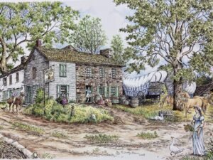 As you drive through town you will see the Clarks Ferry Tavern on your right. The tavern is undergoing restoration and will reopen as a welcome center for visitors as it did in the late 1700’s and early 1800’s. Inside the tavern you will find an interpretative center of the area. The facility is due to open in 2024. Currently it hosts numerous festivals on the tavern green.
During the summer, as you travel through Duncannon, you will see hikers walking the famous Appalachian Trail. Many of the hikers stay at the Doyle Hotel or other businesses located in the center of town. You can have a beverage at the Lindgren Brewery in the repurposed 1924 bank building, adjacent to the Doyle Hotel. Duncannon is northern most urban area on the trail. Just south of Duncannon is Hawk Rock that offers a spectacular view of the Susquehanna Water Gap.
After your visit to Duncannon continue through town and turn south (left) on US 11/15 toward Marysville.
Entering Marysville on the right there is a small viewing platform from which you can get a great view of the famous Rockville Bridge crossing the Susquehanna River. This bridge is the longest stone arched bridge in the world. The bridge was built in 1901 – 1902.
At the other side of town you may get a whiff of freshly baked Lady Fingers as you pass the Specialty Bakers factory right along the road.
About 0.5 miles down the road you will be able to get an extensive view of west end of the Rockville Bridge. Leaves obstruct the view during the summer months. Be careful in this area because there is not much room to get off the road. Marysville is only a few miles from the capitol city of Harrisburg on the other side of the Susquehanna.
Continue south until you find a safe place to turn around, return to Marysville and turn left on SR 850 at the first traffic signal to be installed in Perry County. That happened in 2009. Very little history is written about this valley from Marysville to Shermans Dale. This is a very pleasant drive in the fall as you pass many farms and new home subdivisions on your way to Shermans Dale, 13 miles down the valley. Shermans Dale is another quiet little community nestled among the hills of Perry County. Turn left onto SR 34 southbound and travel about 3 miles to Sterrett’s Gap on the Cumberland Perry County line. At the top of the mountain you will find a plaque on a stone marking the high water mark of confederate soldiers during the Civil War. Turn around at the top of the mountain and return to Shermans Dale, passing through town.
Less than a mile west of Shermans Dale along SR 34/850 you will see a mill that has many names. The mill was built in 1827 by Jacob Stouffer and later known as Louck’s Mill. Other owners since then were Alexander Fleck, Samuel Rebert, the Rev. Henry Brown, Jeremiah Smith, Harrison Brownawell, and T. Luke Toomey. The mill was last used in the late 1940’s.
This mill was given to the historical society in 2013.
Follow SR 34 north 1 mile to Dromgold’s Corner where SR 850 bears left. Turn left on SR 850 and just a few feet in front of you on the right is a state historical marker for William Bigler. The farm behind this sign is known as the Dromgold Farm and has been in the Dromgold family since it was purchased from William Penn in a land grant in 1826. It was given to the Historical Society of Perry County in 2009 in the will of Gladys Schaffer, a descendant of the Dromgold family. Return to SR 34 and turn left to continue north 4 miles to Dellville Road at Meck’s Corner. Turn right on Dellville Road and go 2.4 miles to the village of Dellville where you will find the last and longest covered bridge in the county. Just past the concrete bridge turn right and pass through the covered bridge to a small parking area where you can have a first-rate view of the bridge for a very special picture opportunity.
Return now to Dellville Road, turn right and follow it to SR 274 where you will turn right to take you back into Duncannon. When you reach US 11/15, go under the underpass and turn left onto the on ramp for US 11/15 north. About 0.5 miles north on the right you will see another state historical marker for the Pennsylvania Canal. Continue on 2 miles to the Dauphin/Perry County line near the Ranch House Restaurant where this tour started and now ends.
Once you have completed this tour you will have seen a great deal of Perry County and some of its historical highlights, culture, the way people live, and what it has to offer.
Thank you for taking a drive around Perry County and we hope you had a very enjoyable time. We hope you had an opportunity to meet some of the very nice people and enjoyed the many beautiful “Kodak Moments” during your tour.
Perry County Facts
Perry County was formed on March 22, 1820 from Cumberland County.
It is 47 miles long and 8 to 20 miles wide.
It contains 550 square miles or 1% of Pennsylvania.
Perry County ranges in elevation from 369 feet at Marysville to 2210 feet at Big Round Top near Big Spring Picnic Area.
The population of the county is 44,652 (as of 2004).
There are four public school districts and one military school in the county.
There are two major highways in the county (US 11/15 and US 22/322).
There are two major rivers in the county (Susquehanna and Juniata).
There are fourteen covered bridges and twenty four grist mills.
The first traffic light in the county was installed in Marysville in 2009.
Early History of Perry County, Pennsylvania
The reason Perry County came into existence was due to the considerable population of the area, with the continued incoming of new settlers and the need for frequent trips over the Kittatinny, or Blue Mountain, to the county seat at Carlisle. Most roads were almost impassible during some parts of the year. Because of the challenges getting to Carlisle, settlers north of the mountain presented petitions to the State Legislators to create a separate county so they could travel to a seat of justice without that great natural barrier, the Blue Mountain.
By an act of the State Legislature of the Commonwealth of Pennsylvania and signed by the governor, William Findley, on March 22, 1820 Perry County was created. This territory was part of the lands covered by the Indian treaty at Albany, New York, July 6, 1754. The lands covered by this treaty were all embraced in Cumberland County at that time and the northern part was later formed into Perry, Juniata and Mifflin Counties. When Perry County was formed it was comprised of seven townships lying north of the Blue Hill or Kittatinny Mountains. These townships were: Tyrone, Toboyne, Rye, Greenwood, Juniata, Buffalo and Saville.
Perry County is bounded on the north by the Tuscarora Mountain, separating it from Juniata County, on the East by the Susquehanna River separating it from Dauphin County, on the south by the Kittatinny or Blue Mountain separating it from Cumberland County, and on the west from Franklin County. The natural boundaries of mountains and streams enclose the county to form a triangle that covers 550 square miles. The population of the county in 1820, when the county was created was 11,342.
Landisburg was designated as the temporary county seat when the county was created, pending the selection of a permanent site. The first Court of Common Pleas was convened in Landisburg on December 4, 1820.
Perry County was named in honor of Commodore Oliver Hazard Perry for his actions in the battle of Lake Erie in the War of 1812 with England. The news of his death at the Port of Spain, Island of Trinidad had just reached our shores in the year the county was created. Not only was Perry honored by naming Perry County, Pennsylvania, in honor of him, but counties were also named for him in nine other states: Alabama, Arkansas, Illinois, Indiana, Kentucky, Mississippi, Missouri, Ohio and Tennessee.
You can learn more about the history of Perry County by reading History of Perry County by H. H. Hain, Wright’s History of Perry County, History of Dauphin, Cumberland, Perry, Bedford, Adams and Franklin Counties by I. D. Rupp and several other publications on the subject.
The information presented here was taken from the H. H. Hain and I. D. Rupp publications.
NOTES: